IMD Alerts Extreme Rainfall in Odisha, Telangana, Konkan & Goa (Sept 26‑30, 2025)
When India Meteorological Department (IMD) sounded the alarm at 13:45 IST on September 26, 2025, millions of Indians were startled by the prospect of rain so intense it could break records. The agency, which sits under the Ministry of Earth Sciences and the Government of India, warned of "extremely heavy" downpours – defined as 21 cm or more – across several states during the final week of September.
Why the alert matters now
The monsoon season, which usually eases by early October, has been accelerating its retreat in the northwest while still raging along the east and south‑west coasts. This split pattern means that while Rajasthan and parts of Gujarat are seeing dry spells, states like Odisha and Telangana are bracing for a deluge that could overwhelm drainage, flood plains, and even coastal fisheries.
Forecast details from the September 26 press release
Press Release 4329 – an official weather bulletinNew Delhi – breaks the outlook into three tiers:
- Extremely heavy rainfall (≥21 cm) is expected at isolated spots in Odisha and Telangana on September 26.
- “Heavy to very heavy” rain (7‑20 cm) will blanket Telangana, Coastal Andhra Pradesh, Odisha and Kerala on the 26th and 27th.
- From September 26 through the 30th, the Konkan‑Goa coastline and the ghat belts of Madhya Maharashtra may see the same 7‑20 cm intensity, with a spike of extremely heavy rain on September 28.
The bulletin also flags heavy rain in Marathwada, Vidarbha, and even pockets of northeast India up to October 1.
What’s already happened?
By 08:30 IST on the 26th, IMD’s own observations recorded:
- 7‑20 cm of rain in isolated districts of Tamil Nadu and Kerala.
- 7‑11 cm in the Andaman Islands, eastern Madhya Pradesh, Telangana and parts of Vidarbha.
These numbers line up with the agency’s “heavy to very heavy” category, confirming that the model isn’t just theoretical.
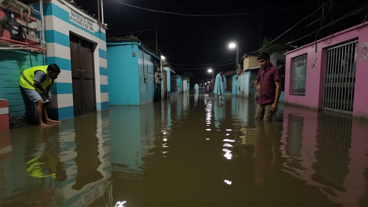
How authorities and locals are reacting
State disaster management committees in Odisha and Telangana have already mobilised rescue teams, sandbag supplies and early‑warning SMS alerts. The district‑wise warning portal (https://mausam.imd.gov.in/responsive/districtWiseWarningGIS.php) shows orange and red zones expanding by the hour.
Fishermen on the east coast received a special advisory through the IMD’s fishermen‑warning portal. The message urged vessels to stay in harbor until at least September 30, citing the risk of sudden squalls and dangerous sea‑state conditions.
Meanwhile, urban planners in Mumbai’s neighbouring Konkan region are urging residents to clear drainage channels, a move that could buy a few crucial hours before streets turn into rivers.
Potential impact on daily life and the economy
Rainfall of this magnitude can cripple agriculture, especially for rice paddies already saturated from the monsoon’s earlier phases. The Agriculture Ministry estimates that an extra 10 cm of rain could cut wheat yields in Telangana by up to 5 %.
Transport networks are also at risk. The Konkan Railway, which snakes along the Western Ghats, has a history of landslides during heavy downpours. A similar event could delay freight movement between Mumbai and Goa, nudging up shipping costs.
On the flip side, water‑starved regions in Rajasthan may benefit indirectly once the monsoon finally retreats, but that relief won’t arrive until after the current week’s storm passes.
What’s next on the weather radar?
IMD’s five‑day outlook stretches to October 1, with a gradual tapering of “heavy” rain in the south and a shift toward “moderate” rain in the northeast. However, the bulletin warns that the southwest monsoon’s withdrawal is uneven – parts of Gujarat have already seen a dry spell, but the system could dip back northward, sparking unexpected showers in the coming weeks.
Experts at the Indian Institute of Tropical Meteorology say the pattern mirrors a 2019 event that caused over 1,200 km of river flooding in the Godavari basin. “If the soil can’t absorb the water fast enough, we’ll see flash floods in low‑lying districts,” noted Dr. Anjali Mehta, a senior climatologist, adding that early evacuations could save lives.
Key take‑aways for citizens
- Stay tuned to the IMD’s district‑wise portal for real‑time updates.
- Follow local government instructions – especially evacuations in flood‑prone zones.
- Fishermen should keep vessels docked until the official warning lifts.
- Travelers on the Konkan‑Goa corridor should expect road closures and possible landslides.
Frequently Asked Questions
How will this rainfall affect farmers in Telangana?
The extra precipitation could saturate fields already at capacity, increasing the risk of water‑logging that harms rice and wheat seedlings. The Agriculture Ministry warns of a potential 5 % dip in wheat yields if the soil remains water‑logged for more than a week.
What should coastal residents in Goa do during the extreme rain forecast?
Residents should secure loose outdoor items, stay away from low‑lying waterways, and heed any evacuation orders from local disaster response teams. The IMD has also advised fishermen to keep their boats in harbor until at least September 30.
Why is the monsoon withdrawing from Gujarat while still heavy in the south?
The monsoon’s western edge retreats faster due to high‑pressure systems over the Arabian Sea. Meanwhile, the Bay of Bengal supplies moisture to the eastern side, keeping rainfall intense in states like Odisha and Telangana.
Are there any travel advisories for the Konkan Railway?
Railway officials have issued a precautionary notice: expect possible delays or temporary suspensions on sections prone to landslides, especially between Ratnagiri and Goa. Passengers should check the official Indian Railways website before departing.
When can we expect the rains to subside?
IMD’s outlook shows a gradual decrease in intensity after September 30, with most affected regions returning to “moderate” rain levels by early October. However, isolated showers may linger in the northeast until the first week of the month.


About Author